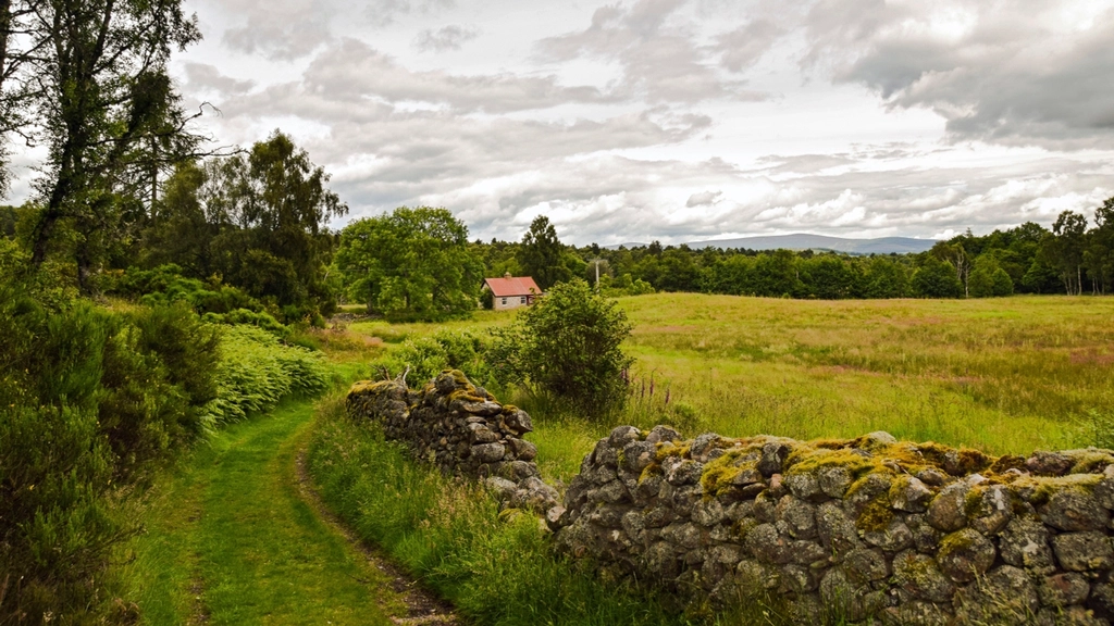
The Forest Is Younger Than It Looks
Walk a quarter mile up almost any wooded slope in the Appalachians and you will eventually cross a straight line of piled stone running through the trees. It goes nowhere, encloses nothing, and has oaks a foot thick growing directly out of it. That wall was built by hand, in the open, by people who could see the whole valley from where they stood.
The single most important thing to understand about the eastern mountain forest is that almost none of it is original. By the early twentieth century, enormous portions of the Appalachians had been cleared for farming, grazed hard, or logged flat. What surrounds most cabins today is second-growth forest, roughly seventy to a hundred and twenty years old, that grew back over abandoned agricultural land. Learning to read that history changes every walk you take. The woods stop being scenery and become a record.
Stone Walls and What They Were For
Stone walls in the Appalachians, as in New England, were rarely built as walls first. They were built as a place to put rocks. Frost heave in a plowed field pushes new stones to the surface every spring, and a farmer clearing a field year after year needed somewhere to stack that annual harvest of rock. The property line and the livestock barrier were convenient by-products.
Reading the construction
- A loose, tumbled, irregular pile means a field edge. These are dump walls or tossed walls, built for disposal. The stones are unsorted, the line wanders slightly, and the profile is broad and low. This was the boundary of ground that was cleared and plowed.
- A neat, faced, double-sided wall means value on both sides. Carefully laid walls with flat faces and capstones took real labor, and they usually mark a property line, a road edge, a house yard, or a livestock enclosure that mattered to somebody.
- A wall with a gap and squared stones is a gateway. Look for a break with worked or notably larger stones on either side and, sometimes, a worn depression in the ground running through it. Gateways tell you where movement happened, which points toward the buildings.
- Two parallel walls twenty feet apart form a lane. Farm lanes moved animals between the barn and the pasture. Follow one and it will very often lead you to a home site at one end and water at the other.
What grows on and around them
Walls are microhabitats in their own right. They shelter chipmunks, snakes, salamanders and wood rats, hold moss and rock ferns, and the disturbed soil beside them often supports different plants than the surrounding slope. If a wall is buried in accumulated leaf litter and soil to half its height, it has been abandoned a very long time. If the stones are still crisp and exposed, the field may have gone out of use more recently than you would guess.
Finding the Home Site
Once you can spot walls, the next step is finding where people actually lived. Old home sites are among the most rewarding things to locate on a piece of mountain land, and they follow predictable rules because the people choosing them had the same basic needs you would.
The signature features
- A flat bench on a slope. Houses need level ground. On a hillside, an unnaturally flat rectangular terrace, usually cut into the uphill side and filled on the downhill side, is the strongest single clue there is.
- A stone foundation or a chimney fall. Even after a house burns or collapses, the fieldstone or brick chimney base and the foundation piers remain. A conical mound of loose brick or fitted stone sitting in a flat spot is a chimney that fell in on itself.
- A depression: cellar, springhouse or privy. A rectangular pit is a root cellar or a house cellar hole. A small stone-lined box near a seep is a springhouse. Approach open holes carefully; old wells and cisterns are genuine hazards, sometimes covered only by rotten boards.
- Water within easy carrying distance. Almost every home site sits within a couple hundred feet of a spring or a reliable stream. If you find the spring first, walk outward from it and look for the bench.
- Terraces, dry-laid retaining walls, or a ramp. Barn foundations often have a ramp up to an upper level and are noticeably larger than the house foundation nearby.
The plants that outlived the people
Vegetation is often the loudest signal of all, visible from a distance and legible in almost any season.
- Daffodils and jonquils in a straight line. Bulbs persist for a century and multiply as they go. A drift of daffodils blooming in March in the middle of the woods is a doorstep or a garden edge, essentially every time.
- Apple and pear trees. Gnarled, broad-crowned old fruit trees, usually in an open-grown shape with low spreading branches, indicate an orchard or a dooryard. Their form tells you they grew up in sunlight, not in forest.
- Lilac, forsythia, privet, periwinkle and yucca. None of these are native forest plants. A lilac in a hollow marks a house corner. Periwinkle carpeting the ground frequently marks a family cemetery.
- Black locust and eastern red cedar. Both colonize open, disturbed ground and cannot regenerate in shade. Big old locusts and cedars standing inside a closed forest are remnants of a field or a fencerow.
- Boxwood or a walnut in an odd place. Both were commonly planted at homesteads and long outlive the buildings they were planted beside.
Reading the Trees Themselves
Trees record land-use history in their shape, and the shape survives long after the surrounding forest has closed in over it.
Wolf trees
A wolf tree is a large tree with a short, thick trunk and enormous low horizontal limbs, standing in a forest of tall, straight, narrow-crowned trees. It looks wrong, and that is exactly the point. It grew in a pasture or a fencerow with no competition, spreading sideways because it could. The forest around it grew up decades later, competing for light and forced to grow straight and tall. A wolf oak is a signpost that says: this was open land, and I was the shade tree.
Even-aged stands and species mix
Second-growth forest that colonized an abandoned field tends to be even-aged: the trees are all roughly the same diameter because they all started within a few years of each other. A stand with a wide range of sizes, canopy gaps, standing dead snags and big fallen logs on the ground is closer to an old-growth structure. Pioneer species tell the same story — a stand dominated by tulip poplar, black locust, red cedar, sassafras or Virginia pine is almost always growing on land that was once cleared. A cove with mixed-age hemlock, sugar maple, basswood and buckeye, deep leaf litter and mossy downed logs may be genuinely old.
Scars and cut stumps
Barbed wire swallowed by a growing trunk dates a fence line. Wide, weathered stumps far larger than any living tree nearby are the ghosts of a logging era. Fire scars at the base of oaks record old burns. Sugar maples with rows of healed tap holes were once part of a sugar bush.
The Ground Itself
Look down as much as you look up. Land shape is the most durable record of all.
- Roadbeds and sunken traces. A shelf cut into a slope with a berm on the downhill side is an old road or a logging grade. Wagon and sled roads erode into shallow sunken lanes over the course of a century.
- Plow terraces and lynchets. Repeated plowing on a slope pushes soil downhill, creating faint step-like terraces that show best in low winter light with the leaves off.
- Charcoal hearths. In iron-producing districts, look for round, flat, level circles roughly thirty feet across cut into the slope, with black charcoal-flecked soil underfoot. These are colliers’ hearths from the charcoal iron era.
- Rock piles that are not walls. Isolated stone heaps in a former field are simply clearing piles. Take care, though: some stone piles in the region are Native American in origin and are culturally significant sites that should never be disturbed.
How to Investigate Responsibly
Old land is fragile and, in many cases, legally protected. There is a large difference between reading a site and damaging it.
- Do not dig. Surface observation and photographs tell you nearly everything you need to know. Digging destroys the context that makes a site meaningful and, on public land, is a federal offense under the Archaeological Resources Protection Act.
- Leave artifacts where they lie. Bottles, ceramics, horseshoes and tools are part of the record. Photograph them in place. On public lands, removing them is illegal.
- Treat cemeteries with respect. Small family plots with uninscribed fieldstone markers are common in these mountains and are protected by law in most states. Do not clear, probe or move stones.
- Stay off private land. A wall in the woods does not indicate abandonment. Know where your boundaries actually run before you go exploring.
- Report significant finds. State historic preservation offices and university archaeology programs are genuinely glad to hear about undocumented sites, and they will often tell you what it is you found.
Tools That Make It Easier
A little desk research turns a vague hunch into a map. Historical topographic maps, available free from the United States Geological Survey, show buildings, roads and cleared land as they existed a century ago; overlaying an old quadrangle on a modern one reveals every vanished structure on your slope. County soil survey maps and the aerial photography flown in the 1930s and 1940s show field boundaries with startling clarity. Where publicly available, lidar-derived hillshade imagery strips the trees away entirely and shows foundations, roadbeds, terraces and charcoal hearths as crisp shadows on bare earth. Deed research at the county courthouse fills in the names.
Then go walking, ideally in late winter. With the leaves down, the undergrowth flattened and the sun low, every terrace edge and every wall throws a shadow. A ridge that looks like undifferentiated forest in July becomes, in February, a legible page: here the field, here the lane, here the house, here the spring, and here the daffodils that somebody planted beside a door that has been gone for eighty years.